7 breathtaking stops in the paradise of adventure trekking – Bat Xat
Bat Xat district is a new Lao Cai tourist area with abundant advantages for thrilling trekking, cultural tourism, and extreme sports.
Interestingly, all tourist sites are located on a closed circular arc passing through different communes of Bat Xat. The infinite rice terraces in the pouring season in The Pa valley, the fairy villages of Ha Nhi people in Y Ty, or the cloudy Ngai Thau mountain, and the awe-inspiring peaks of Ky Quan San are unique spots tourists will discover on the journey to discover this beautiful remote district.
1. About Bat Xat
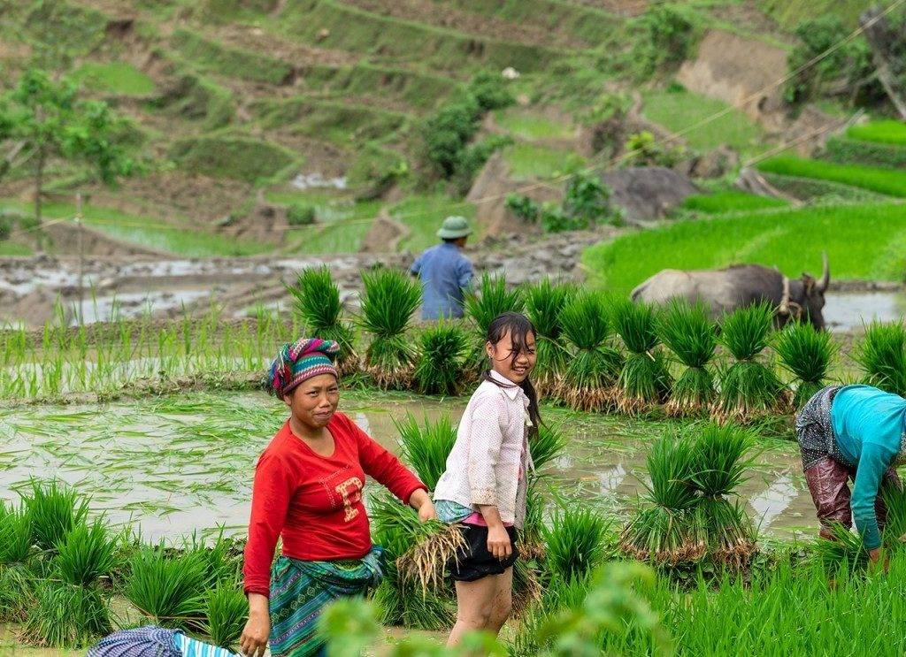
Bat Xat is a highland district bordering China, located in the northwest of Lao Cai province, nearly 300 km from Hanoi. With more than 70% of mountainous terrain, the area develops mainly alpine agriculture; there are 3,000 hectares of terraced fields growing Seng Cu rice – a type of rice typical only in the limestone weathered mountains.
The rich stream system of Ngoi Phat, Lung Po, Quang Kim not only makes important contributions to farming but also become great tourist attractions in the rainy season of the Northwest.
On the journey to discover Bat Xat, besides amazing landscapes, travelers can also learn more about the culture and customs of many local ethnic groups. The Hmong and Ha Nhi have a tradition of farming terraced fields; the Giay grow cotton and weave cloth; the Dao make paper, silver jewelry, and production tools. Additionally, their traditional festivals, such as H’Mong’s Gau Tao festival, Dao’s Suoi Tinh festival, and weekend fair market, should not be missed as well.
Read more: 6 leading hilltribe sites make Lao Cai a must-visit spot
– The weather in Bat Xat
Bat Xat features a tropical climate, hot and humid with lots of rain. Due to the topography, the region is divided into two different climate zones.
Upland: The hot season is from May to October, while the cold season is from November to April next year.
Lowland: The hot season is from May to October, while the cold season is from November to April next year.
– How to get to Bat Xat
From Hanoi, tourists can travel by bus, train, or private vehicles (car, motorbike) to Lao Cai. Then, use available means or rent a motorbike to move to the center of Bat Xat town and its communes.
Here is the fastest and easiest route:
Lao Cai city center → Ly Cong Uan → Hoang Lien → Duyen Ha → Thanh Nien → Ban Qua Bridge → Red River → Provincial Highway 158 → DT155 → Bat Xat.
Read more: WHITE STONE PASS – THE ATTRACTIVE PATH FOR BACKPACKERS
2.The must-visit 7 destinations on Bat Xat
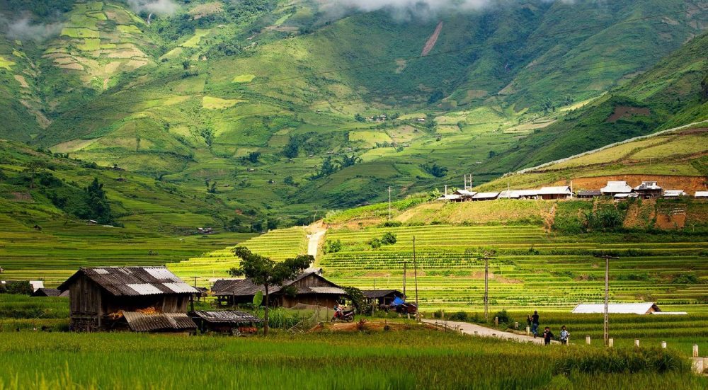
– Rice terraces in The Pa Valley
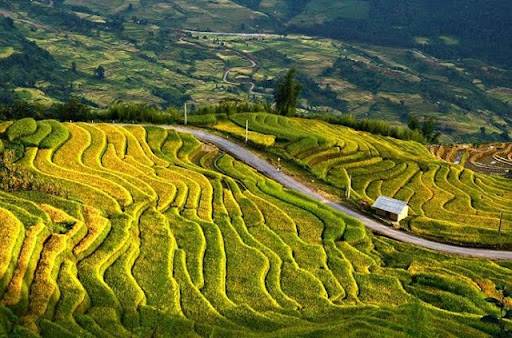
The terraced fields in The Pa valley have an area of 233 hectares, stretching through two communes Y Ty and Ngai Thau. These are the creative works of the H’Mong and Ha Nhi ethnic groups, who have overcome the difficult mountainous terrain to form endless fields as far as the eyes can see, highlighting the region’s landscape.
In the pouring season from April to May, the whole fields are flooded like giant sparkling mirrors reflecting the blue sky. In contrast, In September and October, the place coats a bright yellow color of ripe rice. Currently, the terraced fields in The Pa valley are not only the property of Bat Xat residents but also a national scenic spot.
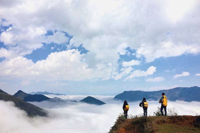
– Ngai Thau Thuong
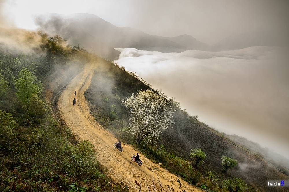
80km from Lao Cai city, along the Vietnam – China border is Ngai Thau Thuong. This is home to a residential area living on the highest terrain of Vietnam, over 2,100 m above sea level. The weather is cloudy year-round, creating a fanciful scene suitable for hunting clouds without climbing the high mountains. The indigenous people are always proud of Ngai Thau’s three Mosts; the most picturesque clouds, the most snowfall in the region, and the most enchanting terraced fields.
The most suitable time to admire the place in the clouds is from November to April next year when the ancient peach forests all bloom on the hill. In addition, visitors can combine trekking or motorbike adventure.
Read more: Sin Suoi Ho – The “stream of gold” village at Son Bac May Mountain
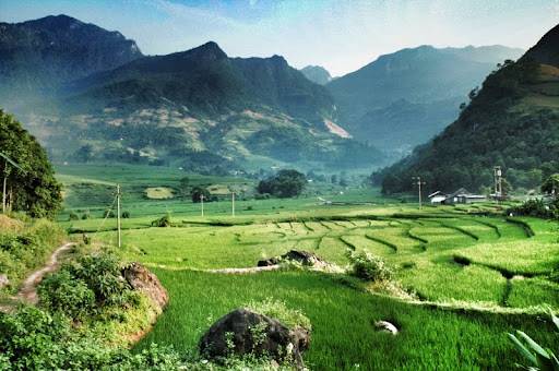
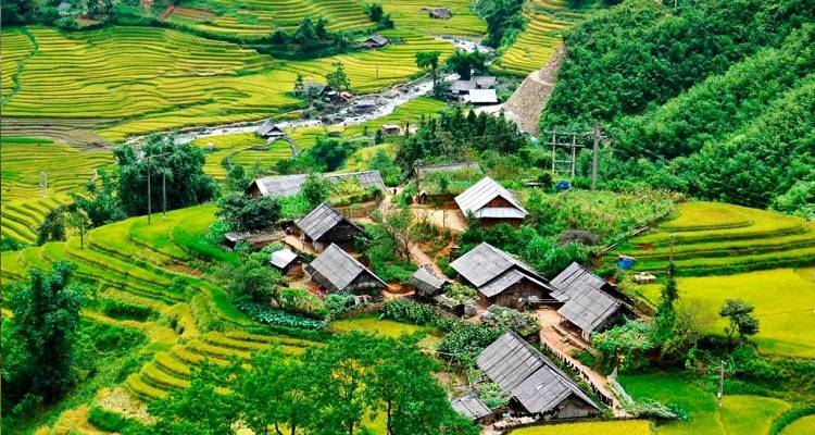
– Y Ty Plateau
As the furthest point in the Bat Xat tourist arc, the pristine Y Ty, up to 2,000m above sea level, stands out in the cloud and winter snow. Dotted at the foot of the high mountain peaks are the terraced fields and villages of the Ha Nhi ethnic group.
Ha Nhi people’s tuong trinh houses are likened to hobbit’s houses with distinctive square shapes made of rammed soil and pointed thatched-grass roofs. Numerous households are gathered along the rustic village road bearing the peaceful fairy beauty.
– Thien Sinh Bridge
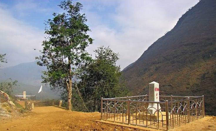
The only 1-meter bridge is located at the end of Lao Chai village, between the border between China and Vietnam. Previously, Thien Sinh Bridge used to be a natural rock crossing the Lung Po stream, but then, the tectonic changes of geology broke the rock layer, forming extremely vivid rock crevices. Standing on the bridge, visitors can see the winding Lung Po stream flowing below and a majestic cliff of about a hundred meters high in front of your eyes.
– Den San Forest
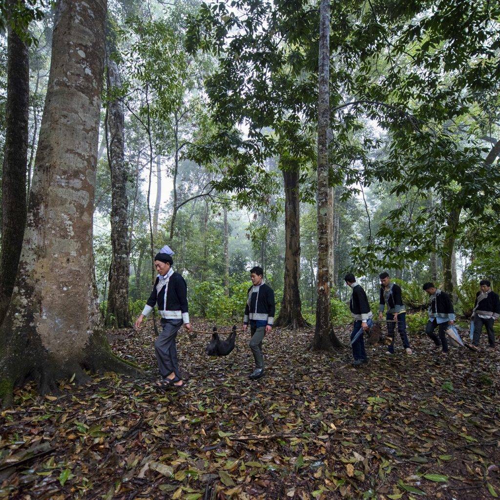
This unique primeval forest is situated in the middle of an arc-shaped rock valley, 8,000 hectares wide, stretching over three communes Y Ty, Den Sang, and Sang Ma Sao. The vegetation here is quite diversified, mixing tropical with subtropical forests and including endemic plants – green cypress, bamboo pine, single-leaf elm, and animals – three-striped turtle, yellow pangolin, salamander, flying squirrel. Not only that, but the Dao also grows cardamom trees here – a spice used in the daily cooking of most Asian countries.
After walking under the ancient trees, visitors will reach a large, flat rock lying peacefully by Red Stream. The natural scenery around is extremely poetic with a cool and airy atmosphere.
– Ky Quan San
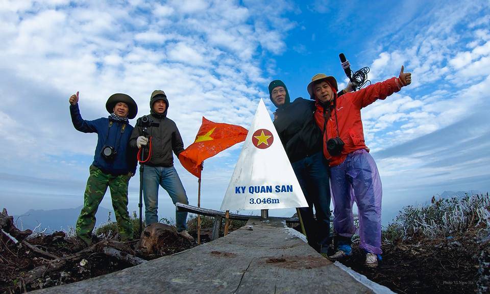
Ky Quan San, also known as Bach Moc Luong Tu, is the highest mountain (3,046 m above sea level) in Ky Quan San village, Sang Ma Sao commune. At the foot of the mountain is the stone road Pavi – an ancient trade route connecting the provinces of Lao Cai – Lai Chau.
Conquering Ky Quan San is much more difficult than Fansipan peak, but the achievement is definitely well-worth. From above, tourists can see a panoramic view of Bat Xat dimly hidden in the floating clouds. Meanwhile, along the trekking route, tourists already experience countless Northwest mountainous terrains with a rich biodiversity of bare hills, bamboo forests, large wooden forests, and moss-covered cliffs.
Read more: Triumph over yourself on the conquest to the highest Indochina’s peak, Fansipan
– Muong Hum Market
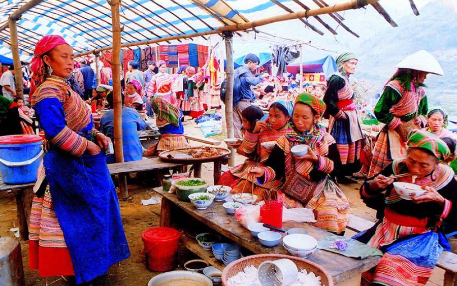
Muong Hum Market, about 20km from Bat Xat center, along Muong Hum stream, is a small weekend fair for Ha Nhi, H’ Mong, and other ethnic minorities to gather, buy, sell and have fun. Here, you will catch Dao people wearing red and black traditional costumes as well as H’Mong in their typical colorful costumes and accessories. They all sell simple items, like food, farming tools, jewelry, and fabrics with the price much cheaper than other places. The market only opens on Sunday mornings and lasts until 2 or 3 pm. Though this stop will not give you a wow scenery, it’s still interesting to visit since you can discover the authentic life of Bat Xat locals.
Read more: Sapa, an absolute landscape treat in the cold of Northwest